Summits On The Air
Last weekend I threw my ham radio gear into a backpack and carried it to the top of South Beacon Mountain in upstate New York, along with with my friend Tom Tumino, N2YTF, and we spent several hours at the summit making contacts with other hams around the globe. Tom is a SOTA enthusiast who has introduced me to this great new aspect of amateur radio. The SOTA program (short for Summits On The Air) encourages hams to get out of the house and operate “mountaintop portable”. Peaks are ranked and assigned point values according to their prominence, with the idea that you want to collect as many points as possible by operating from as many high peaks as you can. The points aren’t good for anything except bragging rights, but it’s a nice incentive to get you out of bed at 7:00 am and on the road.
SOTA is most popular in Europe where they have thousands of peaks cataloged. Here in the US, the program is just gaining momentum, and the administrators are still building the databases of eligible peaks. However there are many portable operators in the states and several other clubs that are active in mountaintopping independent of SOTA. Steve Galchutt wG0AT has created a great series of videos documenting his hikes on Mount Herman in Colorado with his two mountain goats Rooster and Peanut. HFPack is an active organization that focuses on portable and “pedestrian mobile” operations (i.e. backpack radios). Slightly more eccentric is the Polar Bear Club which encourages portable ops in the winter months.
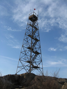
The photo above is of a 70 foot fire tower at the summit of South Beacon that we used as an operating base (you can see our antennas and a SOTA flag at the top if you squint). More photos after the break.
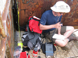
Me (W2VV) sitting in the fire tower making contacts on 20M with a Yaesu FT-857d, NiMH battery, and Buddipole antenna.
![]()
Tom rotates his portable 2M Yagi while holding a Yaesu FT-817.
![]()
A plot of our APRS traffic, showing our real-time GPS position as we made our way up the mountain, from aprs.fi.
Many more photos from this and other activations can be found on my flickr page or Tom’s page.
I really liked this segment and the last radio-oriented one you guys did on using satellites. Keep them coming…
Hi Hams looks like a good afternoon walk from your map and a lot of contacts portable operation yes.
73’s
Barry vk4bas
As if the summit view wasn’t rewarding enough! Hiking and hams looks like loads of fun, hope to hear more on NYCR.
That’s a great idea. keep up the good work fellas and be sure to rattle a few keys. Be safe.
73 de KA5QYR
Badlands of West Texas
Only somebody from “the city” would describe Beacon Mountain as upstate NY- maybe upstate in the sense that you were what, 30 miles north of NYC? Meaning about 110 miles south of Albany, and 250 miles from the Adirondacks, which the rest of people living in the state might describe as “upstate”